Marshall County’s Pioneer Days
Written by Justin D. Lamb
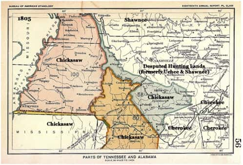
Before white settlers made claim to the land that would eventually become Marshall County, far western Kentucky was inhabited by the Chickasaw Indian tribe. The Chickasaws were one of the three confederations of the Mobilian nation which also included the Creeks and the Choctaws and populated land throughout Kentucky, Mississippi, Tennessee, Alabama, and Missouri. The Chickasaw Indians were a tribe of great hunters and warriors whose towns were located near the Tombigbee River in Mississippi, but their land claims ranged far and wide over the whole Mississippi valley region. Wild game was plentiful in western Kentucky and the region was used as hunting grounds for the ancient tribe. The Chickasaw men were proficient hunters and employed great skill in tracking, trapping and using animal calls and decoys. They caught fish by throwing a poison made with buckeye or green walnut hulls into a deep hole in a stream and spearing or grabbing the drugged fish when they came to the surface. The tribal women collected wild strawberries, persimmons, nuts, acorns, honey and onions. They also dried grapes and plums to make raisins and prunes, and made tea from sassafras root. The Chickasaws painted their faces for ceremonies or making war and shaved the sides of their heads leaving a roach which they soaked in bear grease. A breech clout was the main item of dress accompanied with deerskin shirts. The women wore dresses of finely tanned deerskin and had their long hair tied up neatly.
It wasn’t until 1673 when the first white explores came to the western Kentucky region. Father James Marquette along with five French boatmen with the assistance of the Indian guides set out from Green Bay, Wisconsin on a mission to explore the Mississippi River. According to a dissertation by Patty Vaughn Coakley, “Raising the sails on the canoes, they glided down the mighty father of waters, gazing with wonder upon the magnificent forests that lined its shores and swarmed with game. Continuing their voyage south of the mouth of the Missouri, they passed the mouth of the Ohio, of which river they had heard from the Illinois Indians. As they proceeded the heat became more intense for it was the month of July.”
As the English settled the American continent and colonial independence was declared in 1776, the stage was set for conflict over the Chickasaw lands. The Commonwealth of Kentucky was formed in 1792 from the state of Virginia and pioneers quickly began moving west. Some came from Virginia, while others from Tennessee and the Carolinas. Treaties in 1786 and 1816 guaranteed the Chickasaws the right to the land between the Tennessee and Mississippi rivers. Nevertheless, pioneers continued forging westward and began applying for land grants in the area. Settlers began moving into the land between the Tennessee and Mississippi rivers and frontiersman Banister Wade scouted the area as early as 1817. (Wade would eventually settle the town of Wadesboro in 1820, which was located just south of modern day Hardin.) Due to its prized hunting lands, the Chickasaw Nation valued the section of land and were not easily willing to relinquish it to white settlers.
Kentucky’s seventh governor, Gabriel Slaughter made it his mission to secure the area for white settlers. Slaughter pleaded with President James Monroe who authorized the appointing of two commissioners to negotiate with the Chickasaws for the land. The commissioners chosen were Kentucky’s first governor, Isaac Shelby, and General Andrew Jackson of Tennessee, who had conquered the Seminole Tribe in Florida. After much work and discussion between the two parties, a meeting was called on October 1, 1818 in Cotton Gin Port located on the Tombigbee River in Mississippi. Nineteen days later an agreement was reached and the United States Senate confirmed the treaty which was signed by President James Monroe on January 7, 1819. “The treaty stipulated that the United States would receive lands east of the Mississippi River and north of the Mississippi state line. In exchange, the Chickasaws were to be paid $300,000 at a rate of $20,000 annually for 15 years. The newly acquired land expanded the size of the United States by more than 8,000 square miles, 2,369 of which are in Kentucky. This property constitutes 5.7 percent of the state’s total area.” Today, the region between the Mississippi and Tennessee Rivers in Kentucky is the known as the Jackson Purchase because of General Jackson’s critical role in acquiring the land and in part because of the Chickasaw’s respect and fear of the General. It was reported the tribe did not trust Isaac Shelby which could be an indication as to why Shelby’s name is not included in the naming of the region..
After the departure of the Chickasaws, settlers began moving into the Jackson Purchase by the 1820s, some by foot and wagons, others by boat. The population quickly increased due to cheap land prices of a $1 an acre. By 1829, the price dropped to .25 cents an acre. The land that encompasses Marshall County was first placed as part of the county of Trigg before being placed as a part of Calloway County in 1822. The first to purchase land was Arthur H. Davis. According to a historical marker placed in his honor, Davis represented Calloway County in the state legislature and served as a justice of the peace and sheriff of Calloway County. He also served in the Kentucky militia. His land was located just west of present day Benton near Houser and Jackson School Roads.
Davis wasn’t the only pioneer making his mark in the area. Absolum Johnston and his son Isaac settled in the Sharpe area which then was known as Oakland. Jonathan Grear settled on the Tennessee River near present day Jonathan Creek which was named for Grear. Stephen Howard settled three miles south of present day Calvert City in an area that would become known as Howards Grove. Blacksmith James Brien founded a town just north of Benton which became Briensburg. Hicks Rhea settled at Duncan’s Creek in 1820 and Robert Rose at Soldier Creek. By May 12, 1820, Elder Henry Darnall founded a Hardshell Baptist Church on Soldier Creek. John and Martha Faughn settled near present day Fairdealing. James Goheen purchased several acres at Olive. The community of Palma lay claim to several inhabitants by 1830. The communities of Monkey Den, Little Cypress, and Birmingham existed by 1838. Peter Brewer built a mill on the west fork of Clarks River by 1839 and the community became known as Brewers.
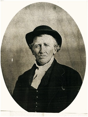
James Brien
By the late 1830s, sentiments began growing to divide Calloway County in half. The driving force behind the movement was James Brien of Briensburg. Brien ran for State Representative of Calloway County and his political opponents charged, “If you elect that scoundrel he will divide this county—literally!” Brien won the election and introduced a bill to form a new county out of the northern section of Calloway County which passed on February 12, 1842. The bill called for Calloway County to be divided where the town of Wadesboro stood thus dooming the town. The new county was named Marshall County in honor of United States Supreme Court Chief Justice John Marshall who had recently passed away. On June 1, 1842, the first court was formed at Spout Spring on Scale Road and organized the local government. The county seat was selected at a central location and the town was named Benton in honor of Senator Thomas Hart Benton of Missouri, a popular Jacksonian Democrat.