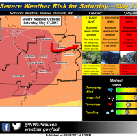
UPDATE: The National Weather Service in Paducah has upgraded the region to a moderate (level 4) risk of severe weather throughout the Memorial Day weekend.
“The moderate risk of severe thunderstorms on Saturday will be initially associated with the development of isolated supercells along the and north of a frontal boundary moving northeast from Southeast Missouri onward to the rest of the Quad State region from mid-afternoon through mid-evening,” NWS forecasts say. “Very large hail and damaging winds will be the primary concern, but an isolated tornado cannot be ruled out near the boundary.”
Significant severe weather potential could begin again late Saturday night and into Sunday morning, when storms move into southeast Missouri and southwest Illinois. Damaging wind will again be a primary concern, according to NWS.
“The most uncertainty in the severe weather and flooding potential will occur between 3 a.m. and 8 a.m. Sunday morning,” forecasts say. “Where the cluster of thunderstorms stalls out overnight, determines where and when the severe weather will occur on Sunday.”
Residents are urged to exercise caution, particularly when planning for holiday weekend activities. For more information, visit weather.gov/pah or follow the US National Weather Service Paducah Kentucky on Facebook.
*****
Original story:
Residents planning a big Memorial Day weekend outdoors may need a contingency plan.
According to the National Weather Service in Paducah, the region is under an enhanced risk to see severe thunderstorms throughout the weekend. NWS forecasts say severe weather could develop beginning tonight, however the worst of the mix will more likely come late Saturday.
The greatest threat remains damaging winds, hail and torrential rainfall, according to NWS; however, isolated tornadoes could also be a possibility.
Severe thunderstorms could continue into Sunday along the cold front into the afternoon and evening.
NWS reminds residents and visitors to take safety precautions where the weather is concerned this weekend:
* Be Aware of the Weather — Know the forecast and check it frequently; be ready for changing weather conditions; plan activities around the weather; have a way to stay informed, such as keeping a NOAA weather radio on hand
* Have a plan of action in place — Know where potential shelters are located; have a plan of what to do if severe weather approaches; and don’t wait to implement that plan
* Brush up on safety tips — Know the difference between watches and warnings; consider lightning safety, if outside and thunder begins go to a sturdy building away from windowns or inside a hard topped vehicle; consider flooding safety, never drive into flooded roads or around barricades, move to higher ground away from creeks and streams; tornado safety, head to lowest floor of building, avoid outside walls and cover head and stay away from windows.
NWS will host a live session with Warning Coordination Meteorologist Ricky Shanklin at 2 p.m. today. For more information or to follow the broadcast, visit US National Weather Service Paducah Kentucky on Facebook.