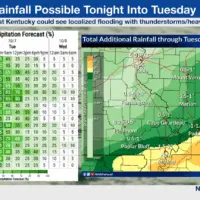
(PADUCAH, Ky.)-A cold front moving through the area is expected to bring widespread showers and thunderstorms from tonight through Tuesday, according to lthe National Weather Service-Paducah.
Western Kentucky is likely to see the heaviest rainfall, with forecasters warning that isolated flooding could occur in some areas.
The unsettled weather pattern will be short-lived, however. Conditions are expected to clear by Wednesday, with dry weather persisting through the remainder of the week.
Temperatures will also drop behind the cold front, with readings forecast to be near or below normal from Wednesday onward.
Residents in western Kentucky should monitor weather conditions closely and be prepared for potential localized flooding in low-lying areas.